Call for Expert Advice
0800 453 422
Official NZ Leica Geosystems Dealer
Free Shipping For Online
Orders Over $50

Training Academy Survey

LEARN FROM THE EXPERTS

Boost your knowledge as you learn from our expert Survey team of qualified instructors who deliver technical training courses designed to deliver professional development and key industry skills.

Indent Triangle 20x20-Max-Quality (2) SURVEYING COURSES

From mastering the introductory principles of surveying to advanced RTK GNSS and coordinate systems, these courses are designed to further the technical ability of NZ Surveyors.

Synopsis:

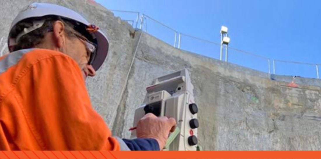
Using a combination of classroom presentation, simulators, software and multiple field sessions, a beginner technician will become comfortable in the use of Leica GNSS and Total Station tools and be able to assess measurements for quality to a basic level.

What you will learn:

Introductions and purpose

Overview of equipment

Introduction to surveying methods

Captivate overview

Field session

Total Station survey – arbitrary grid

Leica Infinity setup and QA

RTK GNSS knowledge and best practise

Field session – GNSS with SmartFIX

Leica Infinity download, QA and tools

Field session – GNSS UHF base/rover

Leica Infinity, download and QA

Field Session – Total Station Resection

GNSS and Total Station combined
Leica Infinity download, TPS processing and QA

Productivity tools as relevant

Leica Infinity

Support tools

Duration: 2 days  
Cost: $3,000

Experience level: Beginner


ENQUIRE NOW Button (1)


Synopsis: 

This course is designed to provide a Leica surveying onboarding experience for staff when they join a new organisation. It is suitable for Surveyors at all levels, where they may have had limited experience using Leica equipment before. The course will be customised to include the equipment and workflows that the organisation currently uses.

What you'll learn:

Introductions and purpose

Discussion around workflows with your current equipment

Overview of Leica equipment

Transition to Leica workflows

Practical job and data management

Introductory Field sessions – equipment as appropriate

Leica Infinity job management, download, QA and tools

Further field sessions – GNSS and/or robotic

Leica Infinity, download and QA

Support tools

Duration: 0.5 -1 Day
Cost: POA

Experience level: Any level from graduate to experienced Surveyor


Enquire Button-1

Synopsis: 

Learn how to set up a GNSS control survey for success (Cadastral or Engineering). Hands on Post Processing of static data and investigate that data for possible errors. Work with both RINEX and raw GNSS data. Use post processed results in a Least Squares Adjustment (LSA software will either be Leica Infinity or MicroSurveys StarNet – depending on the student requirements) and learn how to interpret the results. Free Demo licenses will be available for hose without access to the software

What you'll learn:

How to Plan a Static job

How to execute the job in the field

Importing and Processing data (hands on) in Leica Infinity

Least Square Adjustment of data

Result Interpretation

NOTE: while the post processing of data is in Leica Infinity- all manufacturers RINEX data can be supported, hence open to all.

Duration: 1 Day
Cost: $1,500
Experience level: Beginner to Intermediate


Enquire Button-1

Synopsis:

Using a combination of classroom presentation, software and field sessions, the trainee will develop an understanding of GNSS post processing including campaign design, field data capture, processing, and quality assessment.  


What you'll learn:

GNSS Post Processing scenarios

Equipment capability

Data Logging parameters

Campaign planning

Field data Capture session - static

Field data capture session – PPK

Infinity – getting started

Infinity – Configure processing parameters

Infinity – data processing interpretation and QA - static

Infinity – data processing and QA - PPK

Export options

Support tools

Duration: 1 Day
Cost: $1,500

Experience level: Beginner


ENQUIRE NOW Button (1)


Synopsis:

Using a combination of classroom presentation, simulators, software and multiple field sessions, a competent Leica Captivate user will be exposed to the full range of Captivate configurations and look in more detail at the apps they need to use.  


What you'll learn:

Working Styles – detail of all configuration options

GNSS and Total Station integration

Job Properties – scale factors and Linked Jobs

3D viewer – context menus, DXF/IFC handling, navigation

Coding, linework and attribute settings, including Leica Infinity

Good Captivate housekeeping.

Apps as needed – configurations and optimisation

XSL Stylesheets - Basic introduction

Technical Support and training tools

Duration: 0.5 Days
Cost: $1,000

Experience level: Competent Leica Captivate users


ENQUIRE NOW Button (1)


Synopsis:

Using a combination of classroom discussion and practical hands-on field sessions, a technician working for a contractor will gain an understanding of survey methods and best practise as applicable to the Civil Construction project.  GNSS and Total Station tools will be used during the day. 

What you'll learn:

Course introductions and purpose

Overview of surveying methods

Coordinate systems, projections and height datums

GNSS overview – RTK GNSS operation, how it works, errors and how to handle

Total Station overview – Robotic operation, prism tracking, instrument setup methods

Applications for different equipment, accuracy, QA

Common errors, best practise use of technology

Field session – common site workflows

Equipment hardware

GNSS for control, setout design data, asbuilt checks

Total Station for precise setout

Support tools

Duration: 0.5 Days
Cost: POA

Experience level: 

Construction site technician with experience in the construction environment, but who is starting to perform survey and setout tasks


ENQUIRE NOW Button (1)


Indent Triangle 20x20 Grey Background-Medium-Quality CUSTOMISED TRAINING

  • Customised Survey Workflows

  • Customised Captivate Stylesheets

  • Customised Pointcloud Workflows

Talk to us about your training requirements and how we can tailor a course to fit your specific project or team.

Find Out More Button


Indent Triangle 20x20 No background (2)LEICA E-LEARNING

For product specific training, Leica E-Learning offers a comprehensive range of training courses and e-learning opportunities to all Leica customers. 

Find Out More Button


Indent Triangle 20x20 No background (2)LET'S TALK TRAINING

Enquire here for more information on our Reality Capture training courses.

Enquire Button-1


MEET THE INSTRUCTORS

Tap into decades of knowledge and technical expertise with our team of qualified industry experts.

Bruce-circle

Bruce Robinson

Director & Survey Manager

With more than 30 years experience as a Surveyor, Bruce's specialist areas of interest include geomatics, geodesy, HDS, BIM, IT, and communication technology to improve spatial data capture and analysis. Bruce has been instrumental in developing the SmartFix RTK network.

email-icon768px-LinkedIn_logo_initials

lennon-1

Lennon Bedford

Reality Capture Specialist

Lennon is a Technical Specialist and Christchurch Branch Manager at Global Survey. Lennon's  areas of expertise are in terrestrial and aerial data capture, hybrid processing of point cloud and imagery datasets and the refinement of work-flows for extracting value out of results.

email-icon768px-LinkedIn_logo_initials

richard

Richard Harrison

Survey Specialist

Richard' specialty lays within survey sales, training and support. Richard is passionate about educating our clients, helping them to apply technology in ways that improve the efficiency of information flow from the field through to a valuable deliverable.

email-icon768px-LinkedIn_logo_initials