
![]()
![]()
Numerous changes and improvements have been done on the graphics rendering to boost map zooming, panning and rotation performance. This enables users to work smother and more efficiently with larger files comparing to older versions.

Pending windows updates might cause performance drops, faster battery drainage, network instabilities or even Bluetooth connectivity issues. To prevent those disruptions the software alerts users by showing a message with recommendations to update the windows.

The new iCON field software version supports the colours of the surfaces coming from CAD files (e.g DXF) improving the data interpretation and decision making in the field.
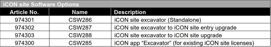
Numerous new functionalities and improvements have been added into iCON site Excavator to ease the workflows and provide more flexibility to the machine operator.

So far, it was possible to offset the design element (surfaces or lines) vertically using the Offset tool from the toolbox.
In the newer version a toggle button is introduced to switch to perpendicular offset.
Depending on the task, the operator can apply a vertical or perpendicular offset to the design surface or line.

Hold slope tool was extending the road models to work outside the design.
In this version it is possible to use the tool and extend surface (terrain) models as well.

A new tool has been introduced allowing the excavator operator to create slopes on the field without requiring design data. A slope can be defined in both X and Y direction based on:
a) the current bucket position or
b) any two points from the map

The new Online map option of a WMS (Web Map Service) has been introduced for version 8.5, providing a great option for free Map images. Multiple layers can be imported in different stages, and they can be handled (turning them on/off) in the Layers Manager

To use IFC files in the Cut & Fill application, install the 928285 CSW268 "Scan & Adv. Surface" license. Once selected, the IFC object turns blue and updates the info panel.
.png "IFC Object (2)")
Updated “Map” and “Cross-Section” indicators: When marking out a road cross slope (road corridor) the distance indicator (dHix) to the daylight point has been incorporated into the map. Furthermore, the Cross Section view has been improved with the addition of the dHix and Cut/Fill labels.
Introduced improvements to the code handling, such as making the description visible in the code group preview and creation screen.
The software now launches on the map screen, with reorganized access to frequently used tools. Along with additions like a convenient menu button and an effortless application switcher, this update significantly enhances user experience, driving efficiency across all your projects.
Jobs can be now created in Leica ConX and seamlessly imported to iCON field, improving data management and user experience.
Users can now switch between different applications faster directly from the map screen without the need to exit to Home Menu. Different elements can be grouped together in the info panel, in order to provide easier access for the user to key functions and smoother navigation on the page configuration.
In the iCON Field v8.0 it is now easier to measure points with codes. The codes get automatically assigned to points in a sequential order, with the newly introduced “Smart coding” feature from the “Measure” application. Multiple code sets with preferred codes can be generated.

After the “Smart code sets” have been defined, the user would need to access the “Quick codes” page to activate the desired “Smart code set” and to choose one of the two available sequence methods:
.jpg "Zig Zag Method (1)")
After the configuration is accepted, the user is redirected to the application, where a split screen will pop up. On the left side the codes which are part of the smart set list are shown and on the right side the map elements.
Before storing the points, the user has the ability to configure the polyline geometry which will influence on how the unique codes will be connected as you measure
The polyline geometry can be changed at any time or even the sequence can be “paused” if a specific point needs to be measured with a code which is not part of the “smart code set”. As soon as the “Smart code” is configured again in the measure bar, the user can measure again from the last point
A new license has been introduced to enable the smart coding functionality on the controller: 996305 CSW292, iCON Smart Coding, for controller.
.png "Log into ConX Server CC200 (1)")
The user can now login from iCON field v8.0 to the cloud server by using the Leica ConX credentials. A new “Project” field has been added to the “Clouds” page.

After the successful login, all the created projects on the Leica ConX server are listed. On top of that, the user can now directly create the project from iCON on the cloud server without accessing the web browser page. This will enhance the workflow of sending design data to another controller or a machine.

In iCON field v8.0 you can export the measured/design data as “avoidance” to the Leica ConX server, making it easier to directly assign it to different machines.

The all-new Hexagon GeoCloud Drive, powered by HxDR, is integrated into iCON field with version 8.0 for file exchange within the entire Hexagon product ecosystem and is available for any user without an additional field SW license. In order to connect, a GeoCloud Drive license needs to be registered as a Service under My Products in myWorld and the required users to be assigned to this registered license. When this is set up correctly the assigned users can authenticate with their myWorld credentials via a browser pop-up and start navigating through their GeoCloud Drive folders and exchanging files in the same way as with any other cloud service.

With 8.0 a new function for controllers called Mini Map will be introduced. The Mini Map feature allows to quickly jump on the map to a different view position while keeping the same zoom level. The Mini Map can be called by tapping on the button above the HOME button. By tapping somewhere in the Mini Map flyout the map view will move to the selected area. The currently visible map content is indicated by an orange frame in the flyout. The North-East rotation will be kept however, the 3D map rotation will be turned back to 2D top view.
.png?width=1200&height=800&name=Page%20Configuration%20CC200%20%20(2).png "Page Configuration CC200 (2)")
.png?width=600&height=400&name=Page%20Configuration%20CC200%20%20(1).png "Page Configuration CC200 (1)")
Small changes in the measure bar config screen will bring a big benefit when customizing the measure bar. The preview of the measure bar is now at the top of the screen and always visible. In case the list of available options which can be configured has to be scrolled, the top options will hide behind the preview bar. As a nice add-on, the lists of options for each button are centred below the appropriate button in the preview bar.
For the info panel config page, the layout has been modernized and simplified. The preview is no longer available on top of the right part but now the different pages listed on the left can be configured directly. Furthermore, the page layout is changed for a cleaner appearance. If a page cannot be configured like the first page of Stakeout applications, the frame and header bar is shown in a light grey colour.
In iCON Site v8.0 it is now possible to create simple trench design models on the field. It is intended to create the trench surface together with the wireframes lines that will follow a road line or any other line/arc element. The user will be able to stakeout the surface, the wireframe lines, but also to calculate the excavation volume for the trench (using a Surface to Surface calculation method). Hence, by calling the “Trench creation” tool from the Volumes application, the user has now the option to define a new trench pattern or to directly work with existing ones


As soon as the user reaches the “Dimensioning” page, a default profile for the trench will be shown. At this point, the depth, length and height values can be modified by directly tapping on the available input fields. The changes will be immediately reflected, and the map preview will update accordingly
At this point the user sets the left cross, respectively right cross slopes to obtain a unique trench profile at a given depth. After the definition of the profile has been done it can be either saved for later use, or applied directly along a road line, arc or line element
It must be mentioned that the start and end values can be adjusted, but it is also possible to add a horizontal/vertical offset. To create the wireframe lines, it is required to toggle on the next button:![]()
By accepting the changes, a new “Save as” screen will pop up, and after the “.xml” file is stored, the user can afterwards directly work with the surface and lines in different applications.
In the iCON Site v8.0 a new tool has been introduced in the well-known “Volumes” application to create a surface by defining slopes along the X and/or Y axis of a line. With the new “Dual slopes” tool the user can create a surface by simply picking just one point from the map to position the surface. In case two points are selected from the map, the slope along Y axis, azimuth, and surface side width values are automatically calculated. Furthermore, a slope along an X axis (perpendicular to Y axis) can be given. The newly created surface can be further used or exported.


The iCON app that was available for BIM360 already has been added to the Autodesk Construction Cloud (ACC) app store as well. This will allow users in addition to also upload / download data to / from their ACC projects from iCON.


New functionality has been introduced in Volumes application giving the ability to define and create exclusion areas (holes) on the measuring surface.
Within the boundary creation mode, press ![]() to start creating surface inner boundaries and form areas that will be excluded from the surface.
to start creating surface inner boundaries and form areas that will be excluded from the surface.
The excluded areas are removed from the volumetric calculations (area and volume calculations).
Additionally, circular objects are now selectable in volumes application for example, to remove the areas of manholes or roundabouts. This was not possible in previous version.

In v7.8 it is now possible to recalibrate and select buckets within the Leica iCON site Excavator application.
Pressing  the relevant angle gets calibrated and the value field shows the mounting offset angle of the sensor.

Points selection has been added to be able to place the bucket on a known point for checking or starting the excavation. This was not possible in previous versions of the software.

Measure bar is enhanced with a Start/Stop line functionality allowing the operator to create lines by measuring points with the bucket or tapping on existing points. It does no longer require to switch to another application (e.g. Draw) to create lines as this can be done directly within the Leica iCON site excavator app.

Automatic point logging functionality has been introduced in v7.8. The operator can now log points automatically using the active tool point or all 3 bucket points (left edge, center and right edge) at a defined distance ot time interval.

The current height of the bucket toolpoint can be set as a height reference with one button press. The workflow to make a surface flat becomes easier now as it is no longer required to store and select the point or type in the height value.
Press the ![]() button to apply the height of the toolpoint as a height reference.
button to apply the height of the toolpoint as a height reference.

Visualisition of the bucket has been enhanced with the introduction of crosshairs and cutting edge indicators. Bucket visibility is improved with the cutting edge line. In addition, it becomes now easier to use the crosshairs to align the bucket with lines and surfaces.

Combining the Cut & Fill View together with the Dual Cut & Fill tool from the toolbox results to a screen showing the Cut & Fill values of the Left and Right bucket edges. This configuration helps the operator to focus more on the excavation work and easier check the status of the excavation.

Sound notification within the Leica iCON site excavator has been introduced in this version. Different sounds can be configured for the height and/or the side distance.
The configurable sound can be triggered when e.g the Cut&Fill (height indication) is within the defined tolerance. To avoid over digging, a different sound can be set together with the threshold value to alert the user when the bucket gets closer to the desired height.


Start the conversation by getting in touch with our specialist team
![]()


.jpg?width=600&height=400&name=Wait%20and%20lock%20(1).jpg)

.png "software")

