.jpg?width=2000&height=604&name=Captivate%20Heder%20(2480%20x%20750%20px).jpg)
Leica Geosystems is committed to the continual development of technology solutions to ensure that our customers are provided with the best possible efficiencies in the field and return on their investment. For this reason, we are pleased to bring you the latest software updates:
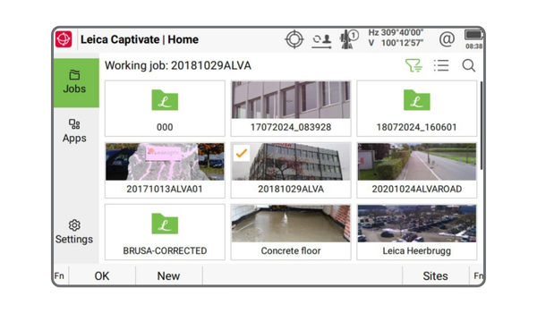
In Leica Captivate v10.00, the home panel has been completely refurbished. The new home panel is divided in three main areas. There is a vertical bar on
the left, that offers three tiles for a quick access to the Jobs, Apps or Settings.
The biggest area to the right of the display, shows all the available jobs, apps or
settings, depending on selected tile. As seen in the screenshot, the function keys bar offers three options.
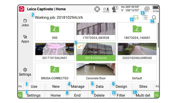
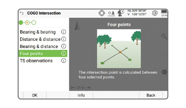
When entering the panel of the selected method, the screen is divided into two areas. One, on the right, shows the map view. The other, on the left, offers a small horizontal bar and bellow it, the different sub-methods that can be used.
The horizontal bar is an indication, within the whole process, of in which step Leica Captivate is. When a step of this process is done, the circle icon belonging to it, will be filled with green colour. Is possible to move back and forth over the different steps of the process.
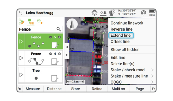
New option to extend and jog an existing measured line. The context menu shows a new Extend line entry. The last point taken for defining the selected line geometry is used as the start point in the Enter Extension Dimension panel. The horizontal distance, offset height and direction of the new point to create can be defined.
By pressing Store (F1), the point is added to the data base and to the selected line, becoming the last point of its geometry. Additional points can be added within this panel, to keep defining the line.
The entry is found in the Measure app’s context menu when selecting an existing line. When tapping on this new entry, the Create Offset Line & Points panel offers the option to define the horizontal & vertical offset values and the point code to assign to the points forming the new line.
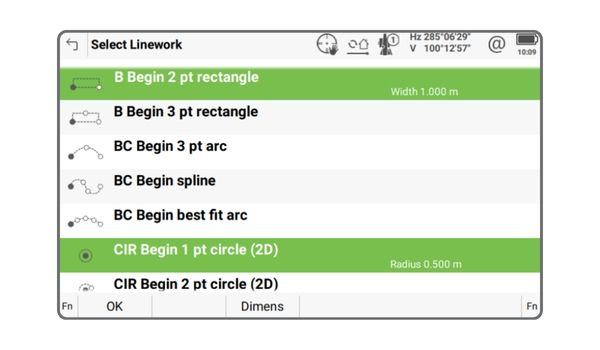
Leica Captivate v10.00 offers two new linework options to offer a quicker way to create circles or rectangles when their dimensions are known and fixed: 1 pt circle (2D) and 2 pt rectangle. Within any app that offers the option to create linework, the Select Linework panel offers the option to define the linework to use. This panel lists the two new linework options. Both new lineworks show a metadata info field on the bottom right part of their rows, showing the value that will be used for creating the geometry when the needed points are measured.
When putting the focus on any of these two new rows, a new button Dimens
(F3) appears. Tapping on it allows to define the width of the rectangle or the radius of the circle. For a quicker definition of which linework and dimension to use, the search field allows typing the key info and proceeding with the selection. To define the 1-point circle, type CIR followed by the dimension you want to use: CIR 1.356. This will create a circle with a radius of 1.356, based on your regional settings distance configuration. To define a 2-point rectangle, type B followed by the dimension you want to use: B 3. This will create a rectangle with a width of 3, based on your regional settings distance configuration.
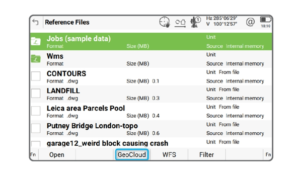
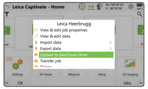
Leica Captivate v10.00 offers a direct option to access GeoCloud Drive service from the Reference Files panel when creating a new job or editing an existing one
Leica Captivate v10.00 shows now, in the status bar on the top of the screen, an indication that the device is connected to GeoCloud Drive.
![]()
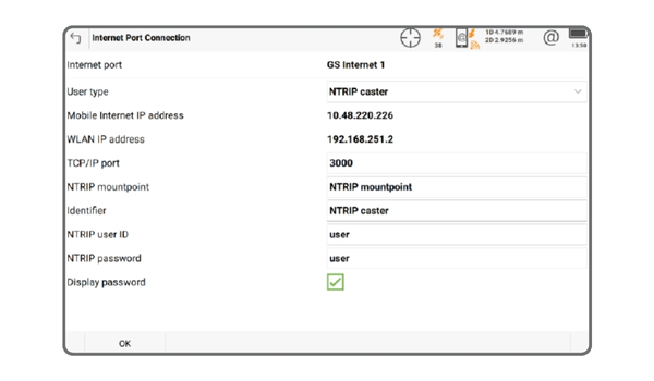
The ability to configure an NTRIP Caster is now available directly through the Captivate user interface. This makes the functionality accessible on all GNSS sensors, including the GS05.
The Leica Captivate software version 9.00 can be loaded onto all CS Field Controllers, GS18 and GS05 GNSS Sensors and TS/MS Total Stations with a valid CCP.
Leica Captivate v9.0 allows switching between apps while continuous distance measurements are active. This means that the measurements do not need to be stopped, allowing a more seamless app switch, especially when using the AP20, which can now maintain the tilt initialisation.
It is now possible to switch between the Measure, Stake points, Stake DTM, Stake points & DTM, Stake to line and Measure to line apps, whilst continuous
distance measurements are active. This improvement means that switching apps is now as simple and quick as pressing a hot key, allowing to maintain a seamless workflow and keep focus on the task in hand.
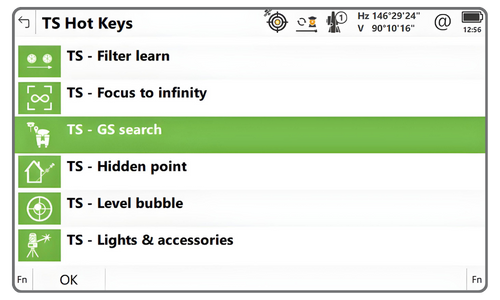
A GS search can be triggered on demand using a Hot key, or automatically after losing lock and prediction has ended.
With Leica Captivate v9.0, when using a SmartPole (a GNSS sensor mounted on the pole together with the prism)a new search option GS search enables the total station to automatically turn directly to the SmartPole target position, before searching for the prism.
The GS search functionality is available when using the combined GS & TS
mode, and the GS has a suitable position available, indicated in the Aim &
Search icon.
.png)
In Leica Captivate v9.0, during target measurements within the Setup app, a new option allows GS & TS mode measurements to be performed automatically with a single press of a button. The option is available for the setup methods of Known backsight, Multiple backsights, Resection and Transfer heights.
Pressing (F4) Meas+TS initiates the GS measurement and then, once stored, automatically initiates the TS measurement. Automating the GS and TS measurement sequence for each measure target point ensures that focus can be kept on the ongoing setup and speeds up the setup completion.
From Leica Captivate v9.0 onwards, enhancements to the inertial navigation algorithms have improved the quality of tilt-compensated RTK measurements. With these improvements, the additional horizontal uncertainty under open sky is reduced to less than 2 mm + 0.3 mm/° tilt down to 30° tilt.
This functionality opens up new possibilities, particularly in drone applications, where Leica GS sensors can be used as a Base station to provide RTK corrections to drones.
Leica Captivate v9.0 for GS18 (and SmartWorx Viva v13.00 for GS10/GS25/GS16) introduces the option to configure an NTRIP Caster when the GNSS sensor is in Base mode. Once all settings are configured, the NTRIP Caster becomes fully functional without any further input needed from Leica Captivate on a controller/tablet.
The onboard NTRIP Server passes the data to the NTRIP Caster that will supports up to 10 simultaneous NTRIP Clients (rovers). Rovers can connect using the displayed GS18 WLAN IP address or, if configured, the Mobile Internet IP address, and access a single mount point.
.png)
The new GS05 GNSS sensor will be supported as a GNSS sensor on the CS20, CS30, CC180 and CC200 Field Controllers.
The Leica Captivate software version 9.00 can be loaded onto all CS Field Controllers, GS18 and GS05 GNSS Sensors and TS/MS Total Stations with a CCP valid until at least 01.10.2024.
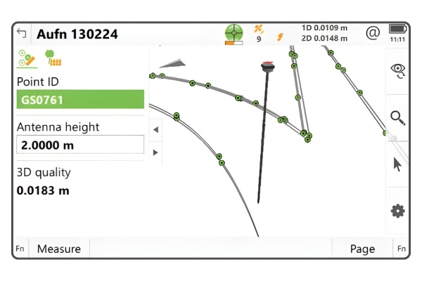
With Captivate v8.50 a tilt strength indicator bar has been introduced, which graphically represents the current tilt initialisation strength, making the user aware of the current tilt quality. When the bar is low, it indicates a decreased tilt initialisation quality, which means further pole movements are required to increase the tilt quality and avoid losing initialisation.
Making the user aware of the tilt initialisation strength ensures that tilt
initialisation can be maintained and maximised, therefore improving productivity, user experience and measurement quality.
.jpg)
Regional configurator tool allows direct access to all the regional-specific files and settings, including user objects and resources, such as working styles, RTK
profiles, codelists, coordinate systems, stylesheets and many other configuration
files and lists.
With an internet connection, the objects within any region can be accessed and
downloaded directly to the field device, ready to be used straightaway.
The Regional configurator can be found within the Tools panel and can be used
without needing a specific license or HxGN GeoCloud account.
The Regional configurator tool supports and recognises all types of Leica
Captivate objects, and automatically places the downloaded objects into the
correct location, so that Captivate can directly use them without any further steps required.
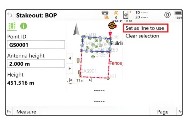
In Leica Captivate v8.50, the option to choose a different line to use from within the Measure or Stake panel has been introduced. Now, all lines from any active job are shown in the 3D viewer and are selectable.
Using the context menu, the option Set as line to use can be used to set the selected line to be the new reference line. This new option ensures that when needing to change the reference line, the ongoing field task is not interrupted by avoiding the need to change panels or stop the measurement process.
In Leica Captivate v8.50, a new snapping tool has been introduced to allow specific points of interest to be easily extracted from attached reference files. Within the map view, the required snapping tool can be activated from the new selection toolbar. Then, by tapping near to a point of interest on a reference object, a temporary snap marker is automatically created at the correct location. Using the context menu, any placed snap markers can be imported as points into the database, or specific functions directly performed such as accessing COGO or Stake apps. There are two snapping tools, for different types of points of interest.
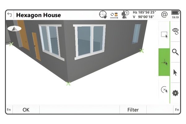
Allows snapping to the start/ends of lines or line segments, and to the corners of solid objects such as polyface meshes or 3D faces. This makes it easy to create individual points at the corners of polylines, such as building corners within a CAD file, or at the corners of solid objects such as walls within an IFC file.
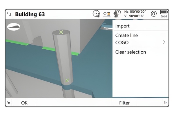
Allows snapping to the centre point of an arc or the centre point of a circle. This makes it easy to create individual points at the centre of circular objects such as the centre of a column within an IFC file. Points created with the snapping tool will automatically have the reference data layer information assigned to the Point code, and for IFC data, include the GUID as an annotation. The snapping tool is available in all map views where multiple object selection is possible, which includes the 3D viewer app, View & Edit data and the Measure app.
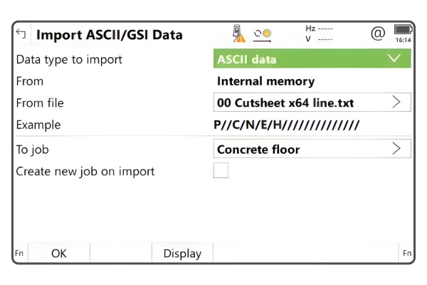
In previous versions of Leica Captivate, when using the Import ASCII data tool,it was not possible to see how the import settings were configured, without going into the settings panel.
From Leica Captivate v8.50 onwards, an example of the data format, based on the configured import settings, is shown in the main import panel. This allows an easy way to check the current settings and proceed with import process.
With Leica Captivate v8.50 the Measurement Engine firmware has been updated to version 7.901. With this version the Precise Point Positioning (PPP) performance is improved in environments affected by ionospheric scintillation to enhance availability and accuracy. When compared to previous firmware versions, this firmware demonstrated up to 60% PPP horizontal accuracy improvements during peak scintillation events. Note that performance varies and is subject to the local environment and the duration and magnitude of scintillation. A vital part of these improvements lies in the combination of multi-constellation and multi-frequency configuration in GNSS receivers.
The Leica Captivate software version 8.50 can be loaded onto all CS Field Controllers, GS18 GNSS Sensors and TS/MS Total Stations with a CCP valid until at least 01.06.2024.

Prompt before storing has been redesigned to be both more simplified and more powerful. There is now only one setting – to switch it on or off, and the display configuration is removed from the settings.

A new play button on each code box gives a touchscreen user the ability to ‘tap to measure’. A single screen tap on the code box will both select that code and trigger a point measurement. This reduces the number of screen taps that are needed for measuring points, allowing to be more productive in the field.
Introducing an innovative feature that enables the storage of Line ID and/or Linework flag as Code information. By activating this setting, whenever a point is saved using linework, the Line ID and/or Linework flag will seamlessly be recorded in the point's Code information field.
The default setting Manually entering still allows the Code information to be entered manually. Be aware that the setting will only apply to subsequently measured points and will not affect already stored points.
This new setting will make it easier for “point based” data exports to contain line information and allow 3rd party software to better interpret your captured data.
In Leica Captivate v8.3, the clarity of when the data filter is active has been increased with the introduction of a data filter status icon. The new icon allows clearly identifying the jobs or datasets that have a data filter active, and therefore may contain points that are filtered out and not visible
the Tunnel axis method has been enhanced with two additional features. The relationship of the design tunnel axis can now be determined with rotation & shift values from an alignment. In addition, the as-built attitude (orientation and pitch) of rings can now be calculated relative to the design trajectory (to deliver “lead” and “look up” values).

A new calculation method Surface to DTM has been introduced. This allows the volume to be calculated between the defined surface, and an existing DTM.
The consistency between all the volume calculation methods has been improved, so that the “from” and “to” are always selected in the same order for every method. This means that the direction of the existing Surface to surface method has been reversed.
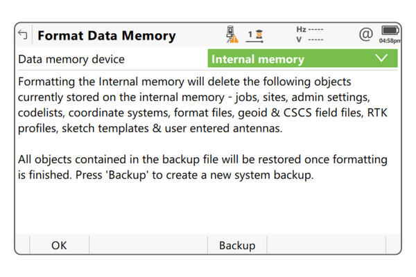
A new Backup option has been added into the Format Data Memory panel. This automatically creates a system backup file, and hence a customised system recovery point
The backup includes all system settings and Leica objects but excludes jobs and data files that are stored in the internal memory.

Introducing the new Tilt Initialization Meter Icon, designed to constantly monitor the strength of the tilt initialization process. When the meter bar starts to decrease or weaken, it serves as a gentle reminder to initiate additional pole movements. This is crucial for maintaining the tilt compensation status and ensuring uninterrupted tilt compensated measurements.
In previous versions of Leica Captivate, certain menus and functions were blocked or hidden when using continuous distance measurements. This restricted access to settings and certain functions unless the measurement was stopped.
However, in Leica Captivate v8.3, these restrictions have been removed, allowing access to settings and tools while keeping continuous distance measurement on. Please note that continuous distance measurements will still need to be stopped if the target type needs to be changed or if the app is switched. This improvement increases productivity, avoids losing tilt initialisation, and allows for a focused measurement workflow.
The Set and Distance buttons are now available in the total station's Remote Control panel. This allows for starting a setup on the controller while triggering distance measurements from the total station, saving time and ensuring consistency in the Setup and Measure apps.
The Leica Captivate software version 8.3 can be loaded onto all CS Field Controllers and TS/MS Total Stations with a CCP valid until at least 01.12.2023
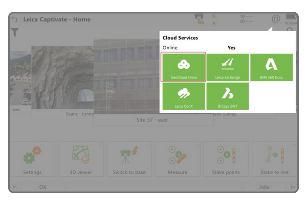
GeoCloud Drive is the first service of HxGN GeoCloud, a cloud-based collaboration portal for measurement professionals. It allows convenient storage, sharing, and access of data in organized projects by field and office crews. Leica Captivate v8.1 supports GeoCloud Drive, enabling easy uploading and downloading of data and Leica objects from cloud-stored projects. No specific GeoCloud Drive for Captivate license is required, but access to a HxGN GeoCloud online account is necessary.
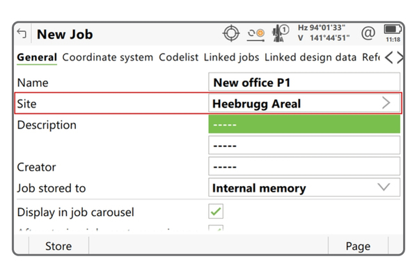
When managing multiple projects and needing to create or use a new job every day or for each task, it can quickly lead to a cluttered memory device with an overwhelming number of jobs. This can make it difficult to locate the specific job you need, especially when relying on the job carousel.
Fortunately, with the latest version of Leica Captivate (v8.00), organizing your jobs has become effortless. Introducing the concept of sites, you can now efficiently categorize and manage your jobs. Simply assign each job to a specific site when creating or editing it, and easily keep track of your tasks.

Topographic surveyors often encounter the task of measuring circular and rectangular objects like inspection covers and manholes. To simplify this process, many third-party software workflows only require 2 or 3 measured points to automatically define the shape.
Three new linework options have been introduced: the 3 pt rectangle, 2 pt circle (2D), and 3 pt circle (2D). These options can be accessed when the Coding functionality is set to Create linework. Now, surveyors can enjoy an enhanced measurement experience with improved accuracy and visibility for circular and rectangular objects.

It is now possible to define up to 60 attributes per point code. The attributes for each code in the codelist can be pre-defined in the Leica Infinity Code Manager or created on-the-fly when measuring in Leica Captivate. Import and export options that previously supported 20 attributes will now support 60 attributes

Previously, accessing the Select Linework panel required tapping the linework icon or pressing the function keys F4(Define) followed by F4(Linework). This could be cumbersome, as it required using the touch screen or pressing two keys.
Now, a new method has been introduced. Simply select a code box and press the Space key on a controller to open the Select Linework panel with just one key press.

There is an increasing trend to exchange data between the field and the office using the internet. The Export data tools now include a new option to allow the exported data to be uploaded and shared via a link within an email

The AP20 Autopole eliminates the need to hold the pole vertical when measuring points. Previously, tilt compensation was available in Leica Captivate measure and stake applications, but not in the Setup application.
It is now possible to perform a total station setup using the tilt compensation functionality of the AP20. In any setup method that uses multiple target points, the backsight or target points can be measured with a tilted pole, and the setup computed taking tilt compensation into account. Note that single target point setups do not support tilt compensated measurements, for example Set orientation and Known backsight. This new functionality allows the full benefits of the AP20 to be gained, increasing the speed and flexibility of the solution even further.
The Leica Captivate software version 8.0 can be loaded onto all CS Field Controllers, GS18 GNSS Sensors and TS Total Stations with a CCP license valid until at least 01.06.2023
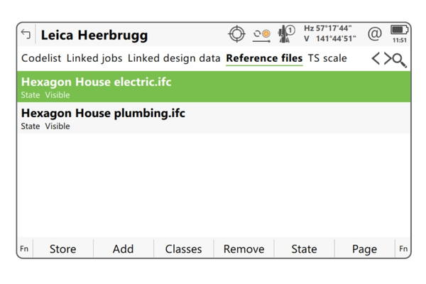
Previous versions of Captivate would allow only one IFC file to be viewed at a time. With Leica Captivate v7.50 it is possible to display the information from multiple IFC files simultaneously, giving a more holistic view of the available design elements in a project.
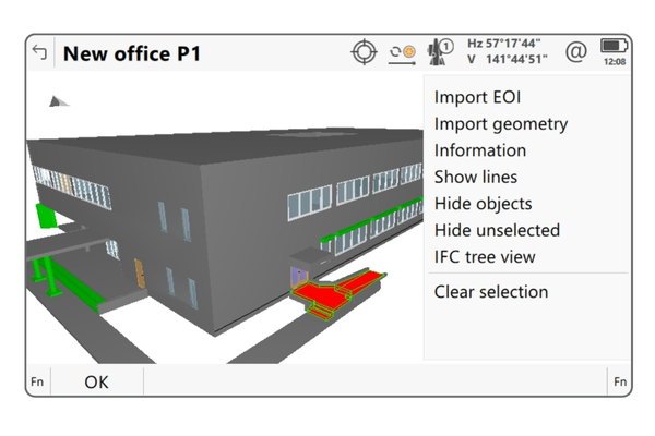
When working with IFC data, the information assigned to each object is very valuable. The common and user-defined property sets of each IFC object can be read and can be displayed. When selecting an IFC object in the 3D viewer, the Information option is shown in the 3D viewer menu.
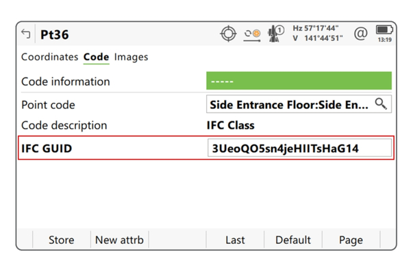
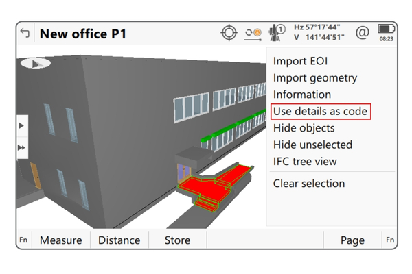
During the building phase, as-built measurements document the final build, allowing for easy comparison to the original design and analysis of any changes. To associate each measured point with the relevant design object, Leica Captivate v7.50 enables the creation of a code using information from the IFC object. In the Measure app, users can select an IFC object in the 3D viewer and choose to use its details as code.
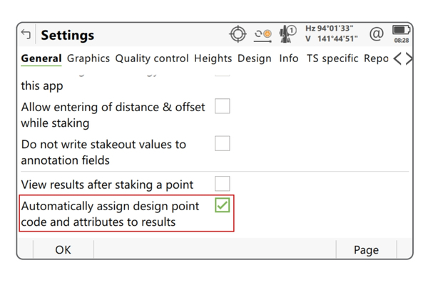
Leica Captivate v7.50 introduces a new feature that allows coding newly created points using the code and attributes from the design point. This feature is available in the Measure to line, Stake to line, and Stake points apps. When working with IFC data, the code attribute 1 of each point created by measuring or staking to the line will contain the GUID from the imported object, enabling automatic matching of measured points to the relevant IFC object.
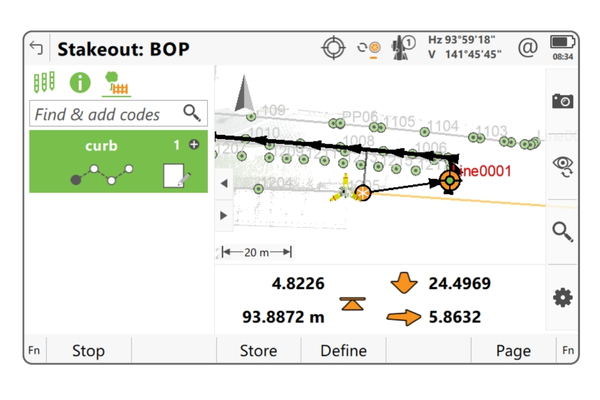
Leica Captivate v7.50 allows measuring and stakeout tasks in one app, including coding and linework functionality. A new extension enables code boxes and linework creation within the Stake points and Stake to line apps. It also offers the option to automatically copy design codes and attributes to staked points. This extension allows for measure and check routines in the same app, with the ability to compare staked/checked data to the original design model.
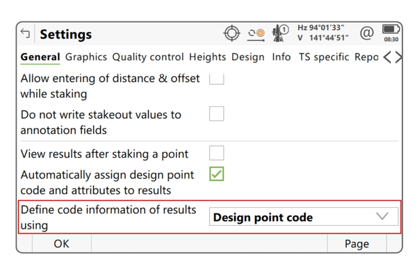
Leica Captivate v7.50 now allows users to automatically populate code information for created points in the Stake points and Stake to line apps, making it easier to code staked points individually while retaining code information from the design point.
This is especially useful when importing design from an IFC object, as it allows the points to be associated with the design IFC object once imported back into the office software.
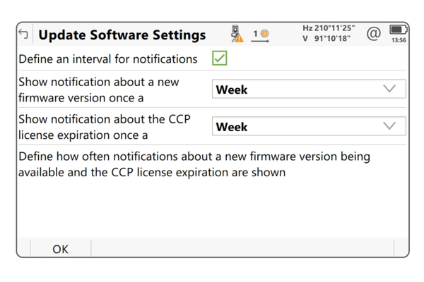
The Update Software panel in Leica Captivate now includes a Settings panel to reduce distraction.
Users can personalize how often CCP expiration and new firmware notifications are shown, from daily to yearly. If the panel is hidden, the notification settings cannot be changed, and no CCP or firmware notifications will be displayed. This allows for customized regulation of messages based on company needs.
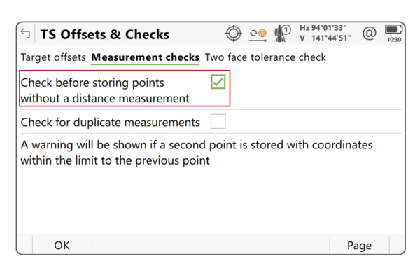
To prevent accidentally storing angle-only measurements, Leica Captivate v7.50 offers a new check that shows a confirmation message when points without a distance measurement are about to be stored.
This check can be found in the Point storage settings, within the TS offsets and checks panel. By default, the check box is activated, displaying warning messages for angle-only measurements unless deactivated.
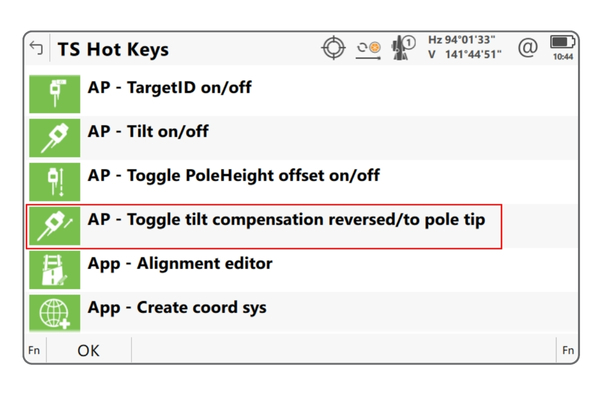
With Leica Captivate v7.50, a new hotkey allows toggling between tilt compensation modes without leaving the app.
Pressing the hotkey turns tilt compensation on and switches the mode instantly. A message confirms the change of tilt compensation modes. It can also be added to the My TS Favorites bubble.
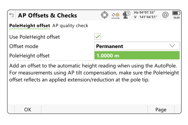
The AP20 PoleHeight feature in Leica Captivate automatically ensures correct pole height measurements. Users can configure and apply a pole extension to each AP20 measured pole height change, even when using an extension to the AutoPole. This new setting in the Point storage settings, AP Offsets & Checks panel, allows for entering an extension to be applied to only the next measurement, including a negative extension height for a worn-off pole tip.
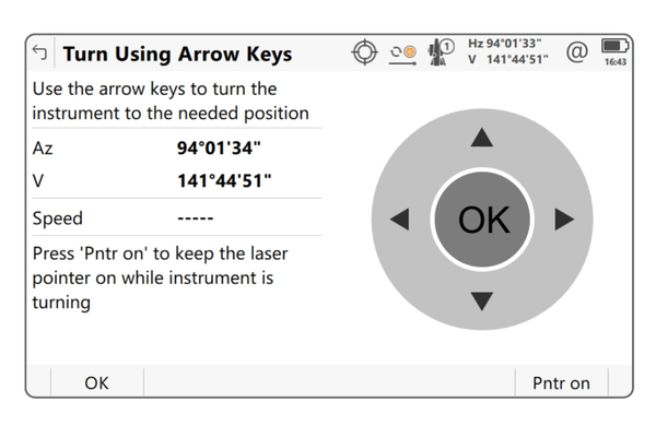
In Leica Captivate v7.50, you can now keep the laser pointer on while turning the instrument using the arrow keys. Simply press the Pntr on (F6) button in the Turn Using Arrow Keys panel to utilize the laser pointer.
The Pntr auto (F6) button allows the laser pointer to automatically turn off again while turning the instrument. This feature is especially useful when positioning the instrument remotely with a CS Controller.
The Check tunnel app offers several methods to check a tunnel profile during the different phases of a project. One of these methods allows scanning a “slice” of the tunnel, meaning the tunnel profile between two chainages. This method can be used with an MS60 MultiStation.
With Leica Captivate v7.50 an additional method specifically for the MS60 MultiStation has been added, which uses the full potential of the MS60. With the As-built by MS band scan method, the MS60 scans the tunnel profile with a speed of up to 30000 pts/s and makes it possible to scan the tunnel profile while the instrument is set up between the defined chainages.
The new method allows for a much-improved work speed and is also more flexible when scanning a tunnel profile by not making it necessary to move an already set up instrument outside the defined chainages.
In comparison to previous versions, an improvement of the RTK availability in challenging environments of over 30% is expected. This includes improved
positioning accuracy and reliability. Note: the position type xRTK, with a typical 3D accuracy of 20cm, has been removed in Leica Captivate v7.50 to instead provide solutions with higher accuracy and reliability.
To get the maximum performance from this improvement, both the GS Sensor and the CS20 Controller or CS30/CS35 Tablet need to be updated to the latest
version
The Leica Captivate software version 7.50 can be loaded onto all CS Field Controllers, GS18 GNSS Sensors and TS Total Stations with a CCP license valid until at least 01.11.2022
Our specialist Survey team work alongside our customers as technical partners, able to provide indepth advice and training. Reach out to them for help with any curly questions or technical challenges.
Get in touch with our team to upgrade to the latest version of Leica Captivate

Richard Harrison
South Island

Bryan Claridge
North Island

Mark Green
North Island